Category Archives: Read Hot and Digitized

Quantitative Criticism Lab, or What Happens When a Classicist and a Computational Biologist Walk into a Bar

Read, hot & digitized: Librarians and the digital scholarship they love — In this series, librarians from the Libraries’ Arts, Humanities and Global Studies Engagement Team briefly present, explore and critique existing examples of digital scholarship to encourage and inspire critical reflection of and future creative contributions to the growing fields of digital scholarship.

The Quantitative Criticism Lab (QCL) was formed in 2014 as a collaboration between humanists, computer scientists and computational biologists. The project’s unique combination of expertise informs its innovative approach to the computational analysis of Latin literature. And I’m not just saying that as a research assistant for the project!

The lab is led by Pramit Chaudhuri, an Associate Professor of Classics at the University of Texas at Austin, and Joseph Dexter, a computational biologist and Neukom Fellow at Dartmouth. They recruited me before I knew what digital humanities was, though I was certain that I wanted to do something more with my Classics undergraduate degree other than teaching fifth graders “Heads, Shoulders, Knees and Toes” in Latin (“Caput, umeri, genua and pedes”, if you were wondering). 

This digital Classics project uses machine learning, natural language processing and systems biology to study Latin literature and its influence. QCL uses a computational approach to explore the traditional study of “philology”, or the development and history of language in text. The lab’s first development was its tool, Fīlum (Latin for the thread of a web), an apt name given the tool’s purpose to reveal relationships amongst Latin texts by identifying intertextual references in Latin literature. 

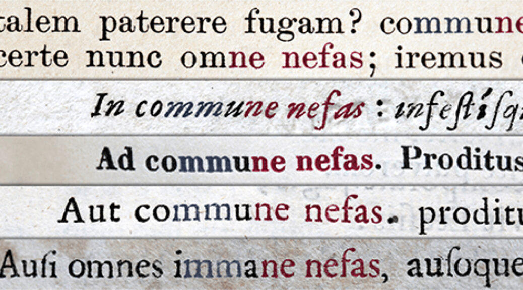
For an example of intertextuality, in the epic poem the Aeneid, Vergil uses the phrase “immane nefas”, meaning “huge wrongdoing” to refer to the unspeakable horrors of the underworld. Years later, the author Lucan, in his epic, the Pharsalia, references and adapts that phrase to “commune nefas”, or “collective wrongdoing”, to blame an entire community for the horrors of civil war. Fīlum aids scholars in discovering, tracking, and discussing such connections. 
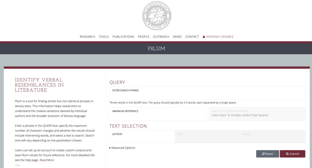
So, what makes Fīlum better than a ctrl+f approach? In the example above, a scholar would have to search many texts to even possibly discover Lucan’s reference; with Fīlum, they can search many texts simultaneously. Furthermore, Fīlum can even detect phrasing similar to the search query. 

QCL’s computational approach tabulates similarity, using the concept of “edit distance”, or the number of character changes through additions, deletions or substitutions in two words or phrases. For example, the edit distance of “kitten” and “sitting” has an edit distance of 3. You substitute “k” with “s”, “e” with “i”, and add a “g” – three changes in total. 

What if you have a feeling the phrase you want to use in Fīlum, might be in a different word order? With “Order-Free” searching, the tool searches for any arrangement of the words in a phrase. This is an especially valuable feature since Latin often refuses to follow a regulated pattern of word order.

With its search phrase, edit distance and order free option, Fīlum searches through a selected text or a user-selected corpora of Latin literature from the site. With a free account, users can create a search corpus from a library of texts or upload their own. 
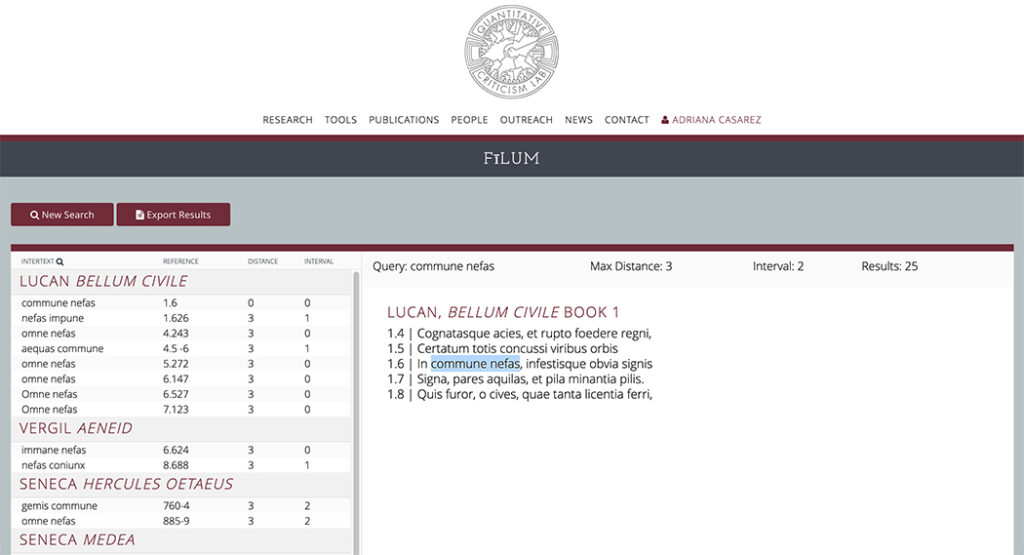
The output cleanly displays results distinguished by each text’s author, work, and highlights the relevant words in each result. For added context, when selected, each result displays the previous and following lines from the text for context.

I have enjoyed both working on Fīlum and using the tool for my research. As QCL continues to improve the tool, I hope other classicists will appreciate not only its value but the interdisciplinary method that built it. 

If you are interested in the project and its study, please stay tuned to information about an upcoming QCL sponsored conference in April, here on the UT Austin Campus:

Digital Humanities Beyond Modern English: Computational Analysis of Premodern and Non-Western Literature https://qcrit.github.io/DHBME/

For further reading on topics like digital classics and text analysis, please see below:

Digital classics outside the echo-chamber teaching, knowledge exchange & public engagement / edited by Gabriel Bodard and Matteo Romanello.

Text Analysis with R for Students of Literature by Matthew L. Jockers.

Critics, compilers, and commentators : an introduction to Roman philology, 200 BCE-800 CE / James E. G. Zetzel.

Philology : the forgotten origins of the modern humanities / James Turner.

UT Library Libguide on Text Analysis by European Studies Librarian, Ian Goodale

Read, Hot and Digitized: South by—The Border Studies Archive at the University of Texas Rio Grande Valley

BY DANIEL ARBINO

Read, hot & digitized: Librarians and the digital scholarship they love — In this series, librarians from the Libraries’ Arts, Humanities and Global Studies Engagement Team briefly present, explore and critique existing examples of digital scholarship to encourage and inspire critical reflection of and future creative contributions to the growing fields of digital scholarship.

The Border Studies Archive (BSA) at the University of Texas Rio Grande Valley (UTRGV) has fostered really interesting digital collections of borderlands materials in recent years. These projects include Traditional Mexican American Folklore; Border Wall and Border Security; Border Music; Latinas and Politics; Spanish Land Grants; and Visual Border Studies. Each of these collections offers insight into a vast array of cultural elements that combine to depict life along the U.S.­–Mexico border.

From non-Western healing practices to government documents on border patrol to land grants, the archive seeks to be as encompassing as possible for local community members and scholars conducting research. In fact, many times these cultural processes challenge the notion of a geopolitical border through transnational production like music, folklore, and curanderismo, as many of these elements exist on both sides of the border. Importantly, much of this information is offered through oral histories and video interviews to retain original voices.

UT Rio Grande Valley Border Studies Archive page.

One of the highlights is the BSA’s Border Music Collection, which contains rare regional music that has been donated by scholars and community members alike. This collection recalls local and now-defunct record companies, musicians of yesteryear, and a genre of local music that is threatened by globalization. But music is just one aspect of the collection. It also includes rare interviews with musicians who discuss their life and what influenced their songs. These interviews come via donations and also interviews conducted by the BSA or students in partnership with the BSA. To that end, the BSA contributes to the growth of its own archive by enlisting university students and the community to record these histories with high-quality equipment. The Border Music Collection continues to digitize old records and CDs for an online collection that offers excerpts of the larger collection.

Video interview with Guadalupe Wally Gonzalez on the UTRGV archive’s Border Music page.

Why go to all this trouble? For the curators, this archive builds a sense of community where everyone can learn something new from interacting with members. Perhaps more significantly, it opposes popular U.S. discourse that the borderland is only a violent space in need of heightened security. On the contrary, the archive portrays a vibrant society alive with unique cultural processes and innovation that has the potential to unite both sides of a border divided by “una herida abierta” (Anzaldúa 1987, 3).

Hidalgo County Land Grant Map, UTRGV Border Studies Archive.

Access to the Collections

University of Texas Rio Grande Valley is employing CONTENTdm to showcase these collections. This platform permits the embedding of different types of content, including audio, video, and text. Only some metadata is supplied with certain files, but the user has to dig around to find it; it’s not easily discoverable on the public-facing side of the site. However, the site’s content is fully available in both Spanish and English, an important recognition of the populations being served. Aside from the need for more robust metadata, there remains an opportunity for further digital scholarship that will surely come with time. The Spanish Land Grants section would benefit from additional visual mapping options like CARTO, for example. However, the current interactive map allows users to click on highlighted areas and watch short videos pertaining to the region.  

For music-related materials at the Benson Latin American Collection, please refer to: The Oscar Martinez Papers, Robert P. and Sugar C. Rodriguez Collection of Tejano Music, the Tish Hinojosa Papers, and the Dan Dickey Music Collection For oral histories, please see: Los del Valle Oral History Project and Voces Oral History Project. Finally, for visual renderings of some traditional healing practices, see Carmen Lomas Garza Papers and Artworks.

Citation

Anzaldúa, G.E. (1999). Borderlands/La Frontera. 2nd ed. San Francisco, CA: Aunt Lute Books.

Read, Hot and Digitized: French Revolution Pamphlets

Read, hot & digitized: Librarians and the digital scholarship they love — In this series, librarians from the Libraries’ Arts, Humanities and Global Studies Engagement Team briefly present, explore and critique existing examples of digital scholarship to encourage and inspire critical reflection of and future creative contributions to the growing fields of digital scholarship.

The French Revolution Pamphlets Digital Initiative, based at the Newberry Library in Chicago, is a large-scale digitization initiative that makes digital copies of over 38,000 documents, mostly pamphlets, accessible online. The documents, which primarily consist of material published between 1780 and 1810, encompass 850,000 pages of text, and the dataset produced by the project, containing OCR and metadata files, is roughly 11 gigabytes. This collection of French Revolutionary materials is among the most comprehensive in the world, and enriches the study not only of French and European history, but casts light on broader concepts of revolution and social transformation relevant to a global audience. The materials are of interest to numerous fields of study, including legal, social, and cultural history and the history of printing and publication.

The homepage for the project, built in Scalar.

The collection gathers materials from a number of the Newberry’s collections, including the French Revolution Collection, the Louis XVI Trial and Execution Collection, and several smaller groups of French Revolution era material. The materials chronicle the political, social and religious dimensions of the Revolution’s history, and include works by a diverse set of authors, including Robespierre, Marat, and Louis XIV. The texts include arguments both in support of and opposing the monarchy between 1789 and 1799, and serve as a firsthand chronicle of the First Republic. The collection includes complete runs of well-known journals, many rare and unknown publications, and about 3,000 French political pamphlets published between 1560 to 1653 that document a period of religious wars and the establishment of the absolute monarchy.

The main interface for the project was built in Scalar, a free and open source web authoring platform from the The Alliance for Networking Visual Culture at USC. The Scalar site links to the digital copies of the pamphlets, hosted on archive.org, as well as translations of select pamphlets. The sites also includes a number of other valuable resources, including data downloads, digital pedagogy materials, and pages designed for librarians interested in working with the digital collection.

The digitized pamphlets on archive.org.

To help support scholarship using the collection, the Newberry has funded an open data grant to support researchers working with the project’s large data set. The recipients of the first grant, Joseph Harder and Mimi Zhou, are conducting a sentiment analysis of the French Revolution materials, assigning numerical values to word-use in order to code for positive and negative tone across the data. By applying sentiment analysis to both the popular press and propaganda, Harder and Zhou hope to find trends in public opinion throughout the French Revolution, and to see how those trends shaped the revolution’s political outcomes.

The project’s data on GitHub.

The project serves as an important contribution to digital scholarship in European Studies. The sheer volume of the project’s digitized materials alone is impressive, but the variety of the resources it encompasses makes it particularly distinctive. Its venture into funding research using an open data grant—and the fact that its data set is openly available to anyone who wants to download it—is especially exciting, and I look forward to seeing the scholarship that results from making these materials freely accessible online. For those interested in exploring French Revolutionary materials in the UT Austin Libraries, I recommend looking through our extensive holdings on the subject, including our collection of pamphlets, both in print and on microfilm.

Read, Hot and Digitized: The Istanbul Urban Database project

Read, hot & digitized: Librarians and the digital scholarship they love — In this series, librarians from the Libraries’ Arts, Humanities and Global Studies Engagement Team briefly present, explore and critique existing examples of digital scholarship to encourage and inspire critical reflection of and future creative contributions to the growing fields of digital scholarship.

The Istanbul Urban Database project, headed by Nil Tuzcu (MIT), Sibel Bozdoğan (İstanbul Bilgi), and Gül Neşe Doğusan Alexander (Harvard), seeks to preserve collective memory and the urban cultural heritage of Istanbul by becoming the most comprehensive online archive of Istanbul’s urban history. The project is based on a digital corpus of maps of Istanbul, aerial imagery, photographs, and geographical features. The project combines this wide range of historical data on a sustainable platform that can be integrated into other projects. The project does not stand alone; there is, in fact, an API in development for serving and exporting the various layers of the information it contains.

With the Istanbul Urban Database, users can select a variety of maps, photos, and other imagery to superimpose over one another, or compare. You can examine one historical map at a time, superimpose them with adjustable transparency, and overlay georeferenced features on the maps. The side-by-side tool allows users to compare maps from two different time periods (currently limited to the 19th and 20th centuries). Uniquely, the project draws on Ottoman and French maps, primarily from the Harvard Map Collection. This allows the user to get a sense of both the internal and external views of Istanbul in the early 20th century.

The map comparison tool.

In terms of infrastructure, the Istanbul Urban Database’s transportation layer hosts information drawn from a 1922 map on ferry, train, and tramway lines. The project organizers decided to present major roads separately because of their impact on city growth. The ferry, train, and tramway lines, and the roads, were drawn by Harvard Mellon Urban Initiative researchers––a quite labor intensive process from which                                                                                                  users benefit immensely. Users also will enjoy having access to Henri Prost’s master plan archives, which have had significant effect on the development of the city of Istanbul. Lastly, users can peruse photographs of everyday life at different points in Istanbul’s history. Examples include beaches, casinos, movie theaters, and patisseries; snapshots of lives well-lived so long ago, in some cases in places that no longer exist.

Looking at spaces of everyday life, including beaches and the spaces of Beyoğlu.

The Istanbul Urban Database project is significant for its combination of resources on an accessible platform with potential for applications in other projects. Istanbul is a difficult city to navigate, let alone understand, today, and so attempting to imagine its past lives might seem rather intimidating for researchers. The Istanbul Urban Database project streamlines access to crucial 20th and late-19th century resources to facilitate research on the growth, structure, and development of the city of Istanbul.

Using the comparison tool between 19th century maps.

I encourage readers to explore all of the tools available, especially the comparison tool that allows you slide two maps right and left to compare time periods. I also suggest looking through the photographs of everyday life that are exhibited through this project, and examine whether or not these places still exist today by zooming into the base satellite map. Readers who are interested in maps of Istanbul and Turkey more broadly would benefit from visiting the UT Maps Collection. The maps of Turkey and specifically Istanbul are extensive and of interest for those piqued by the Istanbul Urban Database.

Read, Hot and Digitized: This is Not an Atlas

Read, hot & digitized: Librarians and the digital scholarship they love — In this series, librarians from UTL’s Arts, Humanities and Global Studies Engagement Team briefly present, explore and critique existing examples of digital scholarship. 

This Is Not an Atlas is a continuation of a book of the same name, subtitled “A Global Collection of Counter-Cartographies.” Critical geography proposes that maps are never neutral, but rather reflect views of the map maker, often those in power. Counter-mapping, or creating counter-cartographies, refers to the use of maps to reframe the world in such a way as to challenge dominant power structures and to articulate alternative, progressive and even radical interests (Kitchin, et al., 2011).

In the spring of 2015, kollektiv orangotango, a self-described network of critical geographers, friends, and activists who deal with questions regarding space, power, and resistance, sent out a call for maps in English, German and Spanish. Overwhelmed by the response and realizing that many of the maps submitted are dynamic, they decided to create a website to, not only highlight projects from the print edition, but also to “continue to share maps, struggles, projects, texts, and inspirations online.” Here I highlight a counter-mapping project that successfully deals with the politics of in/visibility, as described in Emancipatory Mapmaking: Lessons from Kibera.

Map Kibera was initiated after a group of geographers attending a mapping conference in Nairobi, Kenya noticed that Kibera, one of Africa’s largest informal settlements, was not mapped. In fact, they discovered that authorities had labeled and designated the Kibera Slum as a forest. How could a community with an estimated population of 250,000 people be omitted from official maps of Nairobi? Two geographers who were also interested in open source mapping decided they wanted to change this. In October 2009, Mikel Maron and Erica Hagen started the Map Kibera project to address “the glaring omission of roughly a quarter-million of Nairobi’s inhabitants from mass communications and city representation and policy decisions” (Hagen, 2011).

Current (09/09/2019) image of Kibera in Google Maps.
Detail view of Kibera in Google Maps yields little detail about the community.

Kibera is too densely populated to rely on satellite data for mapping. Maron and Hagan knew they would need to map it from the ground. They recruited a dozen young residents to be “mappers,” gave them GPS devices, and sent them to collect data by creating “traces,” a GPS-enabled process that tracks and records your physical location. The mappers interviewed residents and collected observational data, such as the names of clinics, schools, and businesses, locations of water pumps, public baths, and other “points of interest” along their routes as well. The team then added the data to OpenStreetMap (OSM), a crowdsourced world map that relies on user-generated content to create geographic data that is relevant and available to everyone. And within three weeks they had created an incredibly dense map of Kibera for the world to see. But more importantly, a map of Kibera that was extremely useful to residents.

Kibera in OpenStreetMap (09/09/2019)

The project did not stop there; they immediately created, printed, and distributed maps of clinics and schools within the community. And a security map of Kibera warning of areas to avoid and illustrating places to get help. And have since formed the Map Kibera Trust, created the Voice of Kibera, a platform for citizen reporting, and replicated their model in other marginalized communities in Nairobi.

Map Kibera is just one counter-mapping project highlighted in This Is Not an Atlas. Visit the site to discover situational maps defending traditional territories of the Amazon; a documentation of human rights violations in Rio de Janeiro’s Favelas; an anti-eviction mapping project that started in the Bay Area and has expanded its scope; a crowdsourcing project that helps people locate public toilets in an Indian megacity; and many more counter-cartographies.

The book is as beautiful as the website; visit the UT Libraries to see it in person. If you’re interested in learning more about critical geography and counter-mapping, I highly recommend Rethinking the Power of Maps and the Map Reader. Map Kibera initiators, Erica Hagen, and Mikel Maron later founded the Ground Truth Initiative. Visit their project page to find out about other counter-mapping projects they are working with, such as Grassroots Jerusalem.

The China Biographical Database(CBDB) 中國歷代人物資料庫 

Read, hot & digitized: Librarians and the digital scholarship they love — In this series, librarians from UTL’s Arts, Humanities and Global Studies Engagement Team briefly present, explore and critique existing examples of digital scholarship. 


The China Biographical Database is a freely accessible relational database with biographical information of approximately 427,000 individuals as of April 2019, primarily from the 7th through early 20th   centuries. Users can query the system in terms of place, time, office, social associations and kinship, and export the results for further analysis with GIS, social networks, and statistical software.

The China Biographical Database (CBDB) originates with the work of Chinese social historian Robert Hartwell. Hartwell’s research employed data as evidence to form and support his arguments. He built a relational database in dBase for MS DOS format to capture biographical data as it relates to five elements: (1) people, (2) places, (3) a bureaucratic system, (4) kinship structures and (5) contemporary modes of social association. He created an advisory committee for the database and made copies of his datasets and applications available to the committee members. When Hartwell died in 1996, the project included a large number of multi-variant biographical and genealogical data for over 25,000 individuals. He bequeathed his database to the Harvard Yenching Institute. Later, the Harvard Yenching Institute transferred its rights to the Fairbank Center for Chinese Studies and changed its name to the China Biographical Database (CBDB).

Hartwell’s database has since gone through many redesigns to make it work with modern computer technology. The FoxPro application has been used to make easier searches and queries. An online application for public access querying and reporting has been added. Python is used to write procedures for names entity recognition for text-mining and text-modeling. Other facilities that have been built into CBDB includes an XML export ability,  a save/load ability, and a handy list of pre-made regular expression examples. The long-term goal of CBDB is to systematically include all significant biographical material from China’s historical record and to make the contents available free of charge, without restriction, for academic use. Users can query CBDB through an online database in both a Chinese and an English interface. Users can also download the entire database, together with query forms and utilities for exporting data for network and spatial analysis, from the CBDB website and explore the database on any computer with Microsoft Access. 2

The data in CBDB is taken from multiple biographical reference sources, including modern syntheses of biographical data, traditional biographical records, evidence for social associations from literary collections, evidence for office holding from modern and traditional sources, and other biographical databases. 3  Data is regularly being added and updated and is categorized and coded for various aspects of the life histories of Chinese people. The CBDB project also accepts volunteered data as it is thought that the more biographical data the project accumulates, the greater the service to research and learning that explore the lives of individuals.

Research methodologies supported by CBDB:

  • Prosopography
    An investigation of the common characteristics of a historical group by means of a collective study of their lives.
  • GIS: Mapping and Analyzing
    Statistical and geographic information system (GIS) software can be used to work with CBDB data. For example, ArcGIS, MapInfo or even Google Earth can be used to combine freely available China Historical GIS (CHGIS) with CBDB output
  • Social NetworksSocial network analysts find that people need and seek emotional and economic support of different kinds. All social network queries in the stand-alone version of CBDB export data for visualization and some analysis to Pajek, freeware for social network analysis for Windows in UTF-8, GBK or pinyin romanization.

CBDB has grown to be a massive internationally corroboration with three major supporting research institutes.
Fairbank Center for Chinese Studies. Harvard University (US)
Institute of History and Philology. Academia Sinica (Taiwan)
Center for Research on Ancient Chinese History. Peking University (China)

Peter Bol, who was the chair of Hartwell’s advisory committee and a professor of Chinese history at Harvard, is now the chair of the CBDB Project’s executive committee. There are many committees overseeing CBDB: a steering committee (composed of scholars of pre-modern Chinese studies and computer scientists), editorial committees from the participating research institutes, working groups on each of the four historical periods, and functional committees who work on  text mining and web maintenance. All committees are composed of scholars from around the world and CBDB has been promoted widely, for example a recent special program at the 2019 Association for Asian Studies Conference on “Digital Technologies Expo.

References

  1. The Late Robert M. Hartwell “Chinese Historical Studies, Ltd.” Software Project “ / Peter Bol, http://pnclink.org/annual/annual1999/1999pdf/bol.pdf
  2. Chinese biographical data: text-mining, databases and system interoperability / Bol, Peter Kees, Harvard University, http://www.dh2012.uni-hamburg.de/conference/programme/abstracts/prosopographical-databases-text-mining-gis-and-system-interoperability-for-chinese-history-and-literature.1.html
  3. CBDB Sources, https://projects.iq.harvard.edu/cbdb/cbdb-sources
  4. Digital Technologies Expo Schedule (2019 AAS Special Program, https://www.eventscribe.com/2019/AAS/agenda.asp?pfp=dteS

Examples of search and data analysis using CBDB

1.

Search results for Sima Guang

Sima Guang social associates (464 listed, of various types: Patron of, Friend of, Friend in the same graduating class, Impeached, Impeached by, Recommended, Recommended by, Opposed or attacked, Opposed by or attacked by, Praised or admired by, Coalition associate of, Supported by, Purged by, Prefaced book by, Preface of book by, Epitaph written by, Epitaph written for, etc. )

Sima Guang social associates (464 listed, of various types: Patron of, Friend of, Friend in the same graduating class, Impeached, Impeached by, Recommended, Recommended by, Opposed or attacked, Opposed by or attacked by, Praised or admired by, Coalition associate of, Supported by, Purged by, Prefaced book by, Preface of book by, Epitaph written by, Epitaph written for, etc. )

2.

Spatial extent of the marriage networks of the Northern Song statesman Sima Guang and the Southern Song statesman Shi Hao.
Spatial extent of the marriage networks of the Northern Song statesman Sima Guang and the Southern Song statesman Shi Hao. Source: CBDB – https://projects.iq.harvard.edu/cbdb/gis-mapping-and-analyzing


3.


An example of network visualization. The tie can reflect the number of letter between individuals, centered on Neo-Confucians of Zhu Xi
An example of network visualization. The tie can reflect the number of letter between individuals, centered on Neo-Confucians of Zhu Xi. Source: Source: CBDB – https://projects.iq.harvard.edu/cbdb/social-networks


Some examples of biographical indexes included in CBDB  and held in the University of Texas Libraries.

宋元方志傳記索引 / 朱士嘉編 ; 中華書局上海編輯所編輯.
北京 : 中華書局 : 新華書店上海发行所发行, 1963.
DS 735 C5266 1963

遼金元人傳記索引 / 梅原郁, 衣川強編.
京都 : 京都大学人文科学研究所, 昭和47
DS 734 U46

二十四史紀傳人名索引 
北京 : 中華書局 : 新華書店北京發行所發行, 1980.
Z 3106 C387


A 16th Century Digital Library

Read, hot & digitized: Librarians and the digital scholarship they love — In this series, librarians from UTL’s Arts, Humanities and Global Studies Engagement Team briefly present, explore and critique existing examples of digital scholarship. 

“It is astonishing how common this illness is, how it afflicts and torments so many with such grave accidents, that when a man or a woman barely turns 20-years-old they start complaining of melancholy and heartache. Some go about full of fears and shocks, and it is fixated in their imagination that they are about to perish. Others say that a who-knows-what climbs up from their spleen and their belly to their heart, shredding it to pieces.”

Such are the symptoms of depression as described in the first Spanish-language medicine book ever printed in the Americas (Mexico City, 1592), written by Agustín de Farfán. Even though the ailment has not changed, the way we access Farfán’s book has come a long way, from the extremely rare copy of an early American imprint, available in a handful of specialized libraries around the world, to the digital images easily discoverable through Primeros Libros.

What started in 2010 as a joint endeavor by two Texas university libraries and three libraries in the Mexican state of Puebla, is now a collaborative project in which 25 institutions, from California to Massachusetts, from Chile to Spain, have joined forces to digitize the books produced during the first century of the printing press in the Americas, up to 1601.

Primeros Libros is now an outstanding example of international library collaboration.

The goal is to provide digital access to a corpus of 136 titles published in the Viceroyalty of the New Spain (Mexico), where the printing press was established in the year 1539, and 20 titles published in the Viceroyalty of Peru, where the first master printer arrived in 1580.

Users of Primeros Libros might renew their appetite for browsing leisurely in a digital library of very rare books. They could look for the word agua in various indigenous languages, or visit the last pages of the naval engineering book by Diego García de Palacio in search of zingladura (spoiler: it means a day’s travel by ship). Aristotelian logics might be too intricate, at least compared with the modest joy of finding an acrostic poem at the end of Alonso de la Vera Cruz’s Dialectica Resolutio cum Textu Aristotelis.

A page of Alonso de Molina’s Spanish-Nahuatl dictionary. Printed in 1555, this is the first work of lexicography published in the Americas. It contains marginal annotations in Otomí, another language common in Central Mexico. This copy is part of the Joaquín García Icazbalceta Collection, held at the Benson Latin American Collection.

When two or more member libraries own the same title, all copies are digitized and shared on-line, so that researchers can trace ownership, find missing pages, study pen facsimiles, and compare marginal annotations.

Although many a curious thing awaits the casual visitor to Primeros Libros, serious scholarship can be undertaken through this site.

The cross and the sword—religious zeal and military subjugation—were the tools of colonization of the Spanish empire. Primeros Libros is an invaluable resource for understanding the dissemination of the Catholic faith during a period of tremendously violent cultural clashes. To convert the native population, friars became linguists who learned and codified the most widely spoken indigenous languages.

Many titles in Primeros Libros, alongside catechism books that offer the basics of Catholicism, are grammars and dictionaries intended to help missionaries learn the native tongues so that they could preach and pray in the language of the natives.

This formidable linguistic enterprise was undertaken by friars with the aid of natives, not only as speakers of their languages, but also as interpreters and teachers—among the indigenous nobility, some youth were taught Latin and Spanish, and later participated in the elaboration of grammars and dictionaries. Linguistics, anthropology, history of the book, religious studies, philosophy, and history of science—these are some of the disciplinary perspectives enhanced by the Primeros Libros project.

Primeros Libros is a work in progress in which some institutions, already on board with the partnership, are in the process of digitizing their copies. Therefore, not all of the known titles in this corpus are already accessible online. The site will be greatly enriched when the first books printed in Peru become available. Even though the site is not always user-friendly, the inconveniences are minimal compared to the potential for research and education contained in this digital library.


Page from Instrucción Náutica, by Diego García de Palacio, printed in the New Spain in 1587. This copy belongs to the Universidad of Salamanca, in Spain.


Oplontis: A Digital Humanities Success Story from the University of Texas

Read, hot & digitized: Librarians and the digital scholarship they love — In this series, librarians from UTL’s Arts, Humanities and Global Studies Engagement Team briefly present, explore and critique existing examples of digital scholarship. 


When speaking of digital humanities and the field of art history, cautioners of “digital art history” argue that using digital tools is useful only if those tools facilitate an actual rethinking about an object as to its identity and purpose.[1] Certainly, applying quantitative digital methods to an art history project sometime fails to hit the mark for one reason or another. For example, network diagramming, first used with text-based DH projects, does not always successfully transfer to the study of the visual. See the map created in 2013 for the entry to MOMA’s “Inventing Abstraction 1910-1925”, which has been criticized for not providing much insight into the events surrounding the rise of Abstraction (https://www.moma.org/interactives/exhibitions/2012/inventingabstraction/?page=connections). Or in another case, the wonderfully ambitious 2012 project “Mapping Gothic France” (http://mappinggothic.org/) that was originally financially supported by the Mellon Foundation, now languishes because of lack of funding and the untimely death of one of the project’s two creators.

Website of The Oplontis Project.

However, successful digital humanities/art history efforts are happening; one being “The Oplontis Project” (www.oplontisproject.org) impressively initiated 14 years ago, in 2005, here at UT Austin by faculty members, Dr. John Clarke and Dr. Michael Thomas.

This is a mind-bogglingly large project involving numerous specialists’ studies of a villa (Villa A) and a commercial complex at Oplontis, a UNESCO World Heritage site in Torre Annunziata, near Pompeii.

Aerial view of Oplontis site with superimposed plan of actual and hypothetical remains. Drawing Timothy Liddell. © The Oplontis Project

Still going strong, this project involves a growing database for sharing; a website, promoted through Facebook to reach a wider audience (https://www.facebook.com/pg/TheOplontisProject/photos/?tab=album&album_id=335748659810305);  and eventually, 4 volumes of born digital, open access, e-books devoted to the Oplontis Villa A. The 1st volume of this e-book series, on the ancient setting and modern rediscovery of the villa, was published in 2014 (See https://catalog.lib.utexas.edu/record=b8986409~S29). The 2nd volume, which traces the decorations, stucco, pavements and sculpture, will appear this spring 2019. This second volume, alone, contains 2700 high resolution images, a feat that could never be realized in print format. In addition, the e-book format allows for quick links to other material like excavation notebooks.

With the help, among others, of UT’s own Texas Advanced Computer Systems (TAC) (https://www.tacc.utexas.edu/special-report/corral/archeology), members use digital photography and 3-D laser scanning and modeling of wall paintings, mosaics, and sculpture to layer what exists today with digital visualizations that allow the modern viewer to navigate through the rooms as if they were guests in the original villa.  In addition, the site’s gardens were replanted based on pollen and seed analyses; and marble fragments have yielded information about ancient trade routes.

3D model of Oplontis.

I think the success of this digital humanities project can be attributed to several factors. Notably, questions about chronology, function, social structure and landscape that have guided the research at this site, were posited from the very beginning. The huge team of involved specialists firmly grasp how to use digital and scientific tools in the service of research questions for the purpose of yielding new ways of looking at this site and it material culture. Ongoing funding has also been crucial.  And finally, there is the way in which this DH project’s findings have been and will continue to be disseminated.  As John Clarke says, “The 3D model, linked with the database will allow us, and future generations, to find material easily by clicking on find-spots; scholars will be able to share in our work and even add to the information in our database. The model complements the e-book and because the ACLS[2] has graciously offered to make the Oplontis Project publications open access, scholars and laypersons worldwide can benefit from the work of our 42 contributors, coming from a wide range of scientific and humanistic disciplines.”[3]

For more information about Oplontis and other surrounding sites see:

Leisure and luxury in the age of Nero : the villas of Oplontis near Pompeii, 2016, https://catalog.lib.utexas.edu/record=b9138737~S29

“The Villa of Oplontis”, in Preserving complex digital objects, 2014, https://catalog.lib.utexas.edu/record=b8960178~S29

Tales from an eruption : Pompeii, Herculaneum, Oplontis : guide to the exhibition, 2003, https://catalog.lib.utexas.edu/record=b5889687~S29

The natural history of Pompeii, 2002, https://catalog.lib.utexas.edu/record=b5389520~S29


[1] See Johanna Drucker, Is There a “Digital” Art History , Visual Resources, v. 2

[2] The American Council of Learned Societies Humanities E-book series is the publisher of The Oplontis E-book volumes

[3] See the John Clark interview https://notevenpast.org/new-digital-technologies-bring-ancient-roman-villa-to-life/


Read, Hot and Digitized: Footprints – The Chronotope of the Jewish Book

Read, hot & digitized: Librarians and the digital scholarship they love — In this series, librarians from UTL’s Arts, Humanities and Global Studies Engagement Team briefly present, explore and critique existing examples of digital scholarship.  

Working as a book conservator back in the days in Tel Aviv, I was always intrigued by the notes and scribbles found on flyleaves, covers, and pages of centuries-old books. It seemed that this text, which supposedly was not related to the actual content of the book in hand, had its own story to tell – about places, people, and events. Now this data is playing the main role in Footprints; these pieces of information could be interlinked, and show us a new spatial landscape of Jewish texts through generations.

The goal of the project, a collaborative initiative by the Jewish Theological Seminary, Columbia University, University of Pittsburgh, and Stony Brook University, is to create a “database to track the circulation of printed ‘Jewish books’ (in Hebrew, other Jewish languages, and books in Latin and non-Jewish vernaculars with Judaica contents).”[1] Those notes, scribbles, and ‘marginal’ pieces of information are scattered in many forms. Footprints lists many types of evidence while documenting the movement of books, and presents visualizations of mobility, including mapping. Some types of evidence include owners’ signatures and bookplates; handwritten notations of sales; estate inventories; references to exchanges of books in correspondence of scholars or merchants; unpublished booklists copied in flyleaves; printers’ colophons; subscription lists, and lists of approbations indicating backers or patrons of the books who presumably received a copy of the product.[2]

Footprints website.

Take for example the literary work titled ʻAḳedat Yitsḥaḳ (“the Binding of Isaac”) – a collection of philosophical homilies and commentaries on the Torah by Isaac ben Moses Arama (1420-1494).

This text is represented by five different imprints. Each imprint is represented by various unique copies, and each copy has between one to nine ‘footprints.’ For example, the imprint published in 1547 in Venice, Italy, has five unique ‘holdings’ in the database. One of these copies is traced through six different ‘time stamps’, owners, and locations, from 1599 (Modena, Italy) through 1986 (New York, NY). Another fascinating example is the journey of a copy of Masekhet Nedarim (a Talmudic tractate) printed in Venice in 1523. In 1663 it was bought (and sold) in Yemen. Between 1842 to 1894 it was owned by Alexander Kohut in New York, and since 1915 this particular copy has been owned by Yale University, New Haven, CT.

Inscription with details of the sale of Masekhet Nedarim in Yemen, 1663. (https://footprints.ccnmtl.columbia.edu/footprint/6085/)

Librarians and researches from Europe, Israel, and Unites States are constantly adding new information and validating accuracy of current entries. The database currently includes 7638 unique footprints, and is searchable by keywords, footprint year, and publication year. Here in Austin, The Harry Ransom Center is also collaborating with Footprints; data gleaned from the Center’s early Hebrew books holdings, mainly those dated pre-1800, will be uploaded soon to the database.

Footprints is an open-source and open-access tool; it uses a PostgresSQL, an object-relational database system, which is available on Github. As such, it is both a digital humanities project and a global collaborative project. The digital platform makes public the very process of scholarship performed by trusted crowd sourcing. The collaborative platform invites immediate feedback, editing, and revision.[3] The project owners anticipate future uses to include inferential statistical analysis and network visualization. They anticipate that “cultural historians and statisticians would leverage their mutual areas of expertise to offer a statistical analysis that takes into account social, cultural, political, and economic contexts.”[4] In addition, they plan to visualize networks of book movement showing connections between places, and networks connecting individuals to each other or to other places.

Footprints brings to mind Bakhtin’s Chronotope, where time and place are merging into one meaningful experience. A physical printed book travels through times and places; created, owned, and used by various individuals, carrying with it ideas and intellectual meaning. A Chronotope of the Jewish book, Footprints is a multidimensional bibliography, which highlights and makes use of previously unknown resources in a way that re-imagines the practice of Jewish book history.


Further reading (all available at Perry-Castañeda Library)

Pearson, David. 2007. “What Can We Learn by Tracking Multiple Copies of Books?” In Books on the Move : Tracking Copies through Collections and the Book Trade, edited by Robin Myers, Michael Harris and Giles Mandelbrote, 17-37. New Castle: Oak Knoll Press ; London : British Library.

Walsby, Malcolm and Natasha Constantinidu, eds. 2013. Documenting the Early Modern Book World: Inventories and Catalogs in Manuscript and Print. Leiden: Brill.

Dweck, Yaacob. 2010. “What is a Jewish Book?Association for Jewish Studies Review 34: 367-376.

[1] http://footprints.ccnmtl.columbia.edu/about/

[2] http://footprints.ccnmtl.columbia.edu/about/#about02

[3] Michelle Chesner, Marjorie Lehman, Adam Shear, Joshua Teplitsky. “Footprints: Tracking Individual Copies of Printed books Using Digital Methods.” 2018. Medaon, 23. https://www.medaon.de/en/artikel/footprints-tracking-individual-copies-of-printed-books-using-digital-methods/

[4] http://footprints.ccnmtl.columbia.edu/about/#about05


The Infinite Atlas Project, Or a Supposedly Fun Project the Library Didn’t Create

Read, hot & digitized: Librarians and the digital scholarship they love In this series, librarians from UTL’s Arts, Humanities and Global Studies Engagement Team briefly present, explore and critique existing examples of digital scholarship.  Our hope is that these monthly reviews will inspire critical reflection of and future creative contributions to the growing fields of digital scholarship.

David Foster Wallace’s Infinite Jest is considered, by some, a masterpiece of late 20th century American literature. The Harry Ransom Center’s acquisition of Wallace’s personal papers in 2010 gave his work a higher profile among scholars[1], and “Wallace Studies” has emerged as a sub-discipline.[2] Curiously, his writings inspire an obsessive fan base that resembles the enthusiasm and devotion found at sci-fi cons rather than serious literary study.[3] (Wallace had his own obsessions with television and “low-brow” pop culture, and perhaps he would find his fandom amusing.)[4]

I started reading Infinite Jest while I was living in Boston, and I was struck by the novel’s sense of place. Wallace set the novel in a dystopic future where the United States has merged with Mexico and Canada to form the Organized North American Nations. Despite this setting, Bostonians will quickly recognize places in the novel because Wallace reimagines the city in excruciating detail. Critic Bill Lattanzi suggests Wallace was mirroring James Joyce’s painstaking recreation of Dublin in Ulysses. But Lattanzi recognizes what many readers familiar with Boston understand about the novel: There is a distortion of the city in Infinite Jest. It’s not Boston, or even the United States, as we know it. [5]

In this context, I chose to evaluate the Infinite Atlas, an interactive, crowd-sourced mapping project that geo-locates references in Infinite Jest.  William Beutler, a communications consultant, created the Infinite Atlas and the travel blog Infinite Boston in 2012. The site’s “About” section describes it as “an independent research and art project.”[6]

Infinite Atlas 1 Ennet House copy
The Infinite Atlas includes fictional and fictionalized locations unique to Infinite Jest. The Ennet Drug and Alcohol Recovery House is set in the town of Ennet, a fictionalized version of Boston’s Brighton neighborhood.

The Infinite Atlas is built on Google Maps, with design work by the firm JESS3 and programming from the web development company Red Edge. (It’s unclear if Beutler paid for the design and programming.) Beutler credits his friends and family for helping him with data collection, which included going through all 1,000+ pages of Infinite Jest one-by-one. The project also allows users to create their own locations and upload photos and descriptions, so the Atlas has expanded beyond the Boston area.

What can academic institutions take away from this project? What strikes me is the dedication, love, and passion Beutler and his friends brought to it, and their continued maintenance of the Infinite Atlas. Maintenance of digital projects is an ongoing issue for academic institutions and libraries, which can’t afford trendy design firms. However, we can learn from the Infinite Atlas team’s dedication. We should choose projects that we are passionate about, ones that we will care for and attend to in the future, much in the same way we care for our physical book collections.

Infinite Atlas 2 Ryles copy
This is the Infinite Atlas entry for Ryle’s Jazz Club in Cambridge, which was the setting of a notable scene in Infinite Jest and is a place you can actually visit.

This project also has interesting implications for scholars. Infinite Jest is a very difficult book. It is long, convoluted, and full of footnotes. It requires stamina of its readers. If the novel is, as Lattanzi suggests, a fragmentation of Wallace’s experiences in Boston, it is logical that fans would try to make sense of that. Beutler told Fast Company in 2015, “I re-read Infinite Jest after Wallace’s passing, and became obsessed with the idea that there was a way to treat Infinite Jest as a very large data set.”[7] The Infinite Atlas is an attempt to better understand this novel through data, and that is one of digital humanities’ primary goals. Furthermore, the Infinite Atlas could be an object of study unto itself. It is, in a way, a primary source potentially useful for scholars interested in reader response to Wallace’s work. In the universe of digital projects, a non-academic work like the Infinite Atlas is an intriguing example because it challenges our notions of scholarship and leads us to other potentially better questions.[8]

You can find editions of David Foster Wallace’s fiction and non-fiction, including Infinite Jest, at the PCL, where you can also find critical and scholarly works on Wallace’s writing.

[1] Meredith Blake, “What’s in the David Foster Wallace Archive?” The New Yorker, March 9, 2010, https://www.newyorker.com/books/page-turner/whats-in-the-david-foster-wallace-archive

[2] See the Preface to Boswell and Burns’s 2013 book Companion to David Foster Wallace Studies for a brief history of Wallace Studies: http://catalog.lib.utexas.edu/record=b8828072~S29

[3] See fan sites like the Infinite Jest Wiki: https://infinitejest.fandom.com/wiki/David_Foster_Wallace and the Uncyclopedia: http://uncyclopedia.wikia.com/wiki/David_Foster_Wallace And then there’s this particularly, er, challenging essay by Mike Miley in The Smart Set magazine from 2014: https://thesmartset.com/article08181401/

[4] See Wallace’s famous essay “E Unibus Pluram: Television and U.S. Fiction” in his 1997 book A Supposedly Fun Thing I’ll Never Do Again for Wallace’s examination of his own fraught relationship with television: http://catalog.lib.utexas.edu/record=b4267999~S29

[5] Bill Lattanzi, “Messing with Maps: Walking David Foster Wallace’s Boston,” Los Angeles Review of Books, February 6, 2016, https://lareviewofbooks.org/article/messing-maps-walking-david-foster-wallaces-boston#!

[6] “About Infinite Atlas,” Infinite Atlas, accessed February 7, 2019. http://infiniteatlas.com/about

[7] Teressa Iezzi, “Infinite Atlas: A Location-Based Visualization Of A Literary Masterpiece,” Fast Company, January 26, 2015, https://www.fastcompany.com/1681555/infinite-atlas-a-location-based-visualization-of-a-literary-masterpiece

[8] No discussion of Infinite Jest would be complete without its own set of self-aware footnotes.