Category Archives: Read Hot and Digitized

Oplontis: A Digital Humanities Success Story from the University of Texas

Read, hot & digitized: Librarians and the digital scholarship they love — In this series, librarians from UTL’s Arts, Humanities and Global Studies Engagement Team briefly present, explore and critique existing examples of digital scholarship. 


When speaking of digital humanities and the field of art history, cautioners of “digital art history” argue that using digital tools is useful only if those tools facilitate an actual rethinking about an object as to its identity and purpose.[1] Certainly, applying quantitative digital methods to an art history project sometime fails to hit the mark for one reason or another. For example, network diagramming, first used with text-based DH projects, does not always successfully transfer to the study of the visual. See the map created in 2013 for the entry to MOMA’s “Inventing Abstraction 1910-1925”, which has been criticized for not providing much insight into the events surrounding the rise of Abstraction (https://www.moma.org/interactives/exhibitions/2012/inventingabstraction/?page=connections). Or in another case, the wonderfully ambitious 2012 project “Mapping Gothic France” (http://mappinggothic.org/) that was originally financially supported by the Mellon Foundation, now languishes because of lack of funding and the untimely death of one of the project’s two creators.

Website of The Oplontis Project.

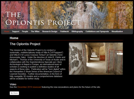
However, successful digital humanities/art history efforts are happening; one being “The Oplontis Project” (www.oplontisproject.org) impressively initiated 14 years ago, in 2005, here at UT Austin by faculty members, Dr. John Clarke and Dr. Michael Thomas.

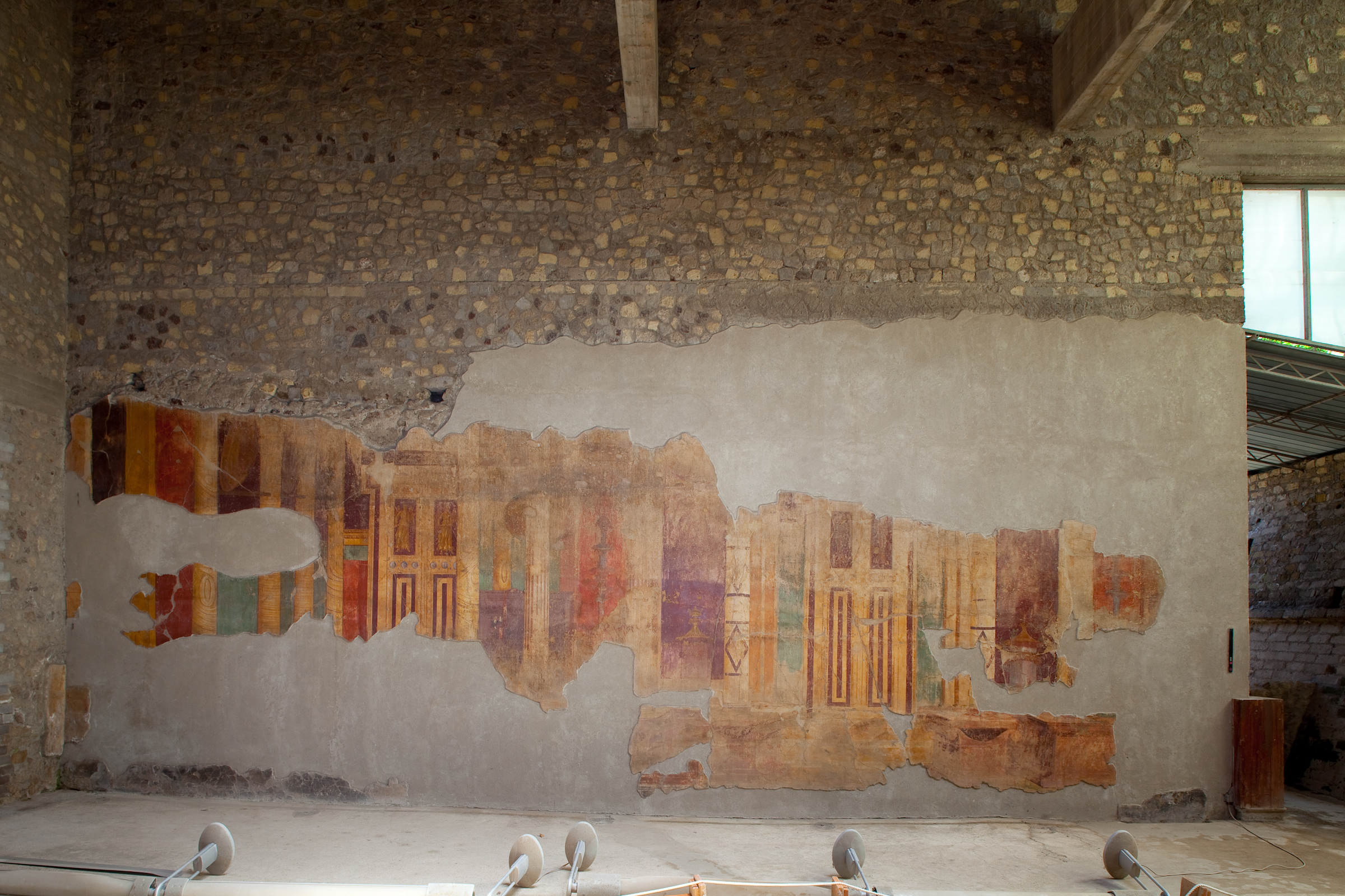
This is a mind-bogglingly large project involving numerous specialists’ studies of a villa (Villa A) and a commercial complex at Oplontis, a UNESCO World Heritage site in Torre Annunziata, near Pompeii.

Aerial view of Oplontis site with superimposed plan of actual and hypothetical remains. Drawing Timothy Liddell. © The Oplontis Project

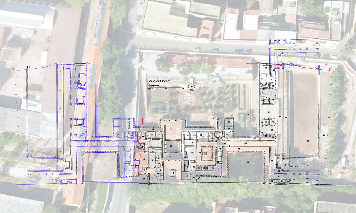
Still going strong, this project involves a growing database for sharing; a website, promoted through Facebook to reach a wider audience (https://www.facebook.com/pg/TheOplontisProject/photos/?tab=album&album_id=335748659810305);  and eventually, 4 volumes of born digital, open access, e-books devoted to the Oplontis Villa A. The 1st volume of this e-book series, on the ancient setting and modern rediscovery of the villa, was published in 2014 (See https://catalog.lib.utexas.edu/record=b8986409~S29). The 2nd volume, which traces the decorations, stucco, pavements and sculpture, will appear this spring 2019. This second volume, alone, contains 2700 high resolution images, a feat that could never be realized in print format. In addition, the e-book format allows for quick links to other material like excavation notebooks.

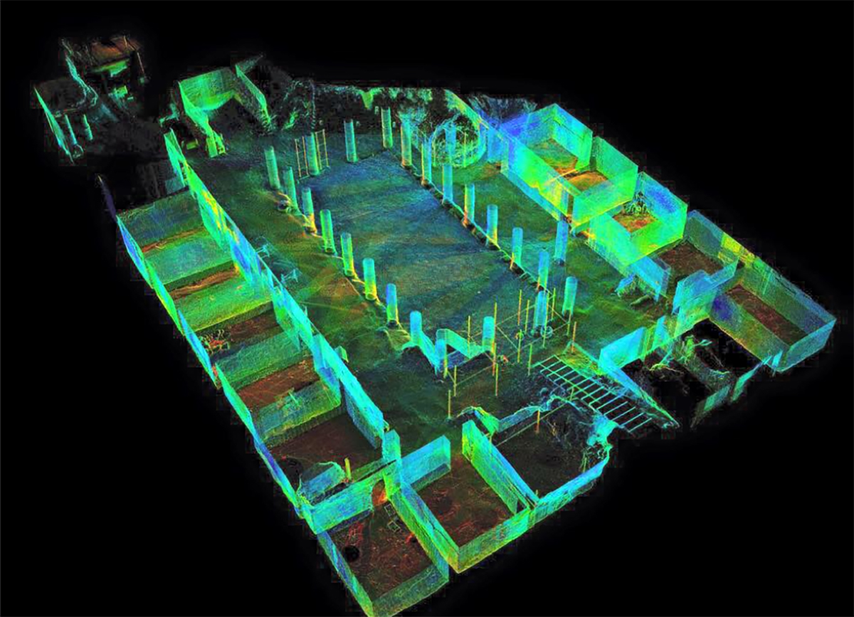
With the help, among others, of UT’s own Texas Advanced Computer Systems (TAC) (https://www.tacc.utexas.edu/special-report/corral/archeology), members use digital photography and 3-D laser scanning and modeling of wall paintings, mosaics, and sculpture to layer what exists today with digital visualizations that allow the modern viewer to navigate through the rooms as if they were guests in the original villa.  In addition, the site’s gardens were replanted based on pollen and seed analyses; and marble fragments have yielded information about ancient trade routes.

3D model of Oplontis.

I think the success of this digital humanities project can be attributed to several factors. Notably, questions about chronology, function, social structure and landscape that have guided the research at this site, were posited from the very beginning. The huge team of involved specialists firmly grasp how to use digital and scientific tools in the service of research questions for the purpose of yielding new ways of looking at this site and it material culture. Ongoing funding has also been crucial.  And finally, there is the way in which this DH project’s findings have been and will continue to be disseminated.  As John Clarke says, “The 3D model, linked with the database will allow us, and future generations, to find material easily by clicking on find-spots; scholars will be able to share in our work and even add to the information in our database. The model complements the e-book and because the ACLS[2] has graciously offered to make the Oplontis Project publications open access, scholars and laypersons worldwide can benefit from the work of our 42 contributors, coming from a wide range of scientific and humanistic disciplines.”[3]

For more information about Oplontis and other surrounding sites see:

Leisure and luxury in the age of Nero : the villas of Oplontis near Pompeii, 2016, https://catalog.lib.utexas.edu/record=b9138737~S29

“The Villa of Oplontis”, in Preserving complex digital objects, 2014, https://catalog.lib.utexas.edu/record=b8960178~S29

Tales from an eruption : Pompeii, Herculaneum, Oplontis : guide to the exhibition, 2003, https://catalog.lib.utexas.edu/record=b5889687~S29

The natural history of Pompeii, 2002, https://catalog.lib.utexas.edu/record=b5389520~S29


[1] See Johanna Drucker, Is There a “Digital” Art History , Visual Resources, v. 2

[2] The American Council of Learned Societies Humanities E-book series is the publisher of The Oplontis E-book volumes

[3] See the John Clark interview https://notevenpast.org/new-digital-technologies-bring-ancient-roman-villa-to-life/


Read, Hot and Digitized: Footprints – The Chronotope of the Jewish Book

Read, hot & digitized: Librarians and the digital scholarship they love — In this series, librarians from UTL’s Arts, Humanities and Global Studies Engagement Team briefly present, explore and critique existing examples of digital scholarship.  

Working as a book conservator back in the days in Tel Aviv, I was always intrigued by the notes and scribbles found on flyleaves, covers, and pages of centuries-old books. It seemed that this text, which supposedly was not related to the actual content of the book in hand, had its own story to tell – about places, people, and events. Now this data is playing the main role in Footprints; these pieces of information could be interlinked, and show us a new spatial landscape of Jewish texts through generations.

The goal of the project, a collaborative initiative by the Jewish Theological Seminary, Columbia University, University of Pittsburgh, and Stony Brook University, is to create a “database to track the circulation of printed ‘Jewish books’ (in Hebrew, other Jewish languages, and books in Latin and non-Jewish vernaculars with Judaica contents).”[1] Those notes, scribbles, and ‘marginal’ pieces of information are scattered in many forms. Footprints lists many types of evidence while documenting the movement of books, and presents visualizations of mobility, including mapping. Some types of evidence include owners’ signatures and bookplates; handwritten notations of sales; estate inventories; references to exchanges of books in correspondence of scholars or merchants; unpublished booklists copied in flyleaves; printers’ colophons; subscription lists, and lists of approbations indicating backers or patrons of the books who presumably received a copy of the product.[2]

Footprints website.

Take for example the literary work titled ʻAḳedat Yitsḥaḳ (“the Binding of Isaac”) – a collection of philosophical homilies and commentaries on the Torah by Isaac ben Moses Arama (1420-1494).

This text is represented by five different imprints. Each imprint is represented by various unique copies, and each copy has between one to nine ‘footprints.’ For example, the imprint published in 1547 in Venice, Italy, has five unique ‘holdings’ in the database. One of these copies is traced through six different ‘time stamps’, owners, and locations, from 1599 (Modena, Italy) through 1986 (New York, NY). Another fascinating example is the journey of a copy of Masekhet Nedarim (a Talmudic tractate) printed in Venice in 1523. In 1663 it was bought (and sold) in Yemen. Between 1842 to 1894 it was owned by Alexander Kohut in New York, and since 1915 this particular copy has been owned by Yale University, New Haven, CT.

Inscription with details of the sale of Masekhet Nedarim in Yemen, 1663. (https://footprints.ccnmtl.columbia.edu/footprint/6085/)

Librarians and researches from Europe, Israel, and Unites States are constantly adding new information and validating accuracy of current entries. The database currently includes 7638 unique footprints, and is searchable by keywords, footprint year, and publication year. Here in Austin, The Harry Ransom Center is also collaborating with Footprints; data gleaned from the Center’s early Hebrew books holdings, mainly those dated pre-1800, will be uploaded soon to the database.

Footprints is an open-source and open-access tool; it uses a PostgresSQL, an object-relational database system, which is available on Github. As such, it is both a digital humanities project and a global collaborative project. The digital platform makes public the very process of scholarship performed by trusted crowd sourcing. The collaborative platform invites immediate feedback, editing, and revision.[3] The project owners anticipate future uses to include inferential statistical analysis and network visualization. They anticipate that “cultural historians and statisticians would leverage their mutual areas of expertise to offer a statistical analysis that takes into account social, cultural, political, and economic contexts.”[4] In addition, they plan to visualize networks of book movement showing connections between places, and networks connecting individuals to each other or to other places.

Footprints brings to mind Bakhtin’s Chronotope, where time and place are merging into one meaningful experience. A physical printed book travels through times and places; created, owned, and used by various individuals, carrying with it ideas and intellectual meaning. A Chronotope of the Jewish book, Footprints is a multidimensional bibliography, which highlights and makes use of previously unknown resources in a way that re-imagines the practice of Jewish book history.


Further reading (all available at Perry-Castañeda Library)

Pearson, David. 2007. “What Can We Learn by Tracking Multiple Copies of Books?” In Books on the Move : Tracking Copies through Collections and the Book Trade, edited by Robin Myers, Michael Harris and Giles Mandelbrote, 17-37. New Castle: Oak Knoll Press ; London : British Library.

Walsby, Malcolm and Natasha Constantinidu, eds. 2013. Documenting the Early Modern Book World: Inventories and Catalogs in Manuscript and Print. Leiden: Brill.

Dweck, Yaacob. 2010. “What is a Jewish Book?Association for Jewish Studies Review 34: 367-376.

[1] http://footprints.ccnmtl.columbia.edu/about/

[2] http://footprints.ccnmtl.columbia.edu/about/#about02

[3] Michelle Chesner, Marjorie Lehman, Adam Shear, Joshua Teplitsky. “Footprints: Tracking Individual Copies of Printed books Using Digital Methods.” 2018. Medaon, 23. https://www.medaon.de/en/artikel/footprints-tracking-individual-copies-of-printed-books-using-digital-methods/

[4] http://footprints.ccnmtl.columbia.edu/about/#about05


The Infinite Atlas Project, Or a Supposedly Fun Project the Library Didn’t Create

Read, hot & digitized: Librarians and the digital scholarship they love In this series, librarians from UTL’s Arts, Humanities and Global Studies Engagement Team briefly present, explore and critique existing examples of digital scholarship.  Our hope is that these monthly reviews will inspire critical reflection of and future creative contributions to the growing fields of digital scholarship.

David Foster Wallace’s Infinite Jest is considered, by some, a masterpiece of late 20th century American literature. The Harry Ransom Center’s acquisition of Wallace’s personal papers in 2010 gave his work a higher profile among scholars[1], and “Wallace Studies” has emerged as a sub-discipline.[2] Curiously, his writings inspire an obsessive fan base that resembles the enthusiasm and devotion found at sci-fi cons rather than serious literary study.[3] (Wallace had his own obsessions with television and “low-brow” pop culture, and perhaps he would find his fandom amusing.)[4]

I started reading Infinite Jest while I was living in Boston, and I was struck by the novel’s sense of place. Wallace set the novel in a dystopic future where the United States has merged with Mexico and Canada to form the Organized North American Nations. Despite this setting, Bostonians will quickly recognize places in the novel because Wallace reimagines the city in excruciating detail. Critic Bill Lattanzi suggests Wallace was mirroring James Joyce’s painstaking recreation of Dublin in Ulysses. But Lattanzi recognizes what many readers familiar with Boston understand about the novel: There is a distortion of the city in Infinite Jest. It’s not Boston, or even the United States, as we know it. [5]

In this context, I chose to evaluate the Infinite Atlas, an interactive, crowd-sourced mapping project that geo-locates references in Infinite Jest.  William Beutler, a communications consultant, created the Infinite Atlas and the travel blog Infinite Boston in 2012. The site’s “About” section describes it as “an independent research and art project.”[6]

Infinite Atlas 1 Ennet House copy
The Infinite Atlas includes fictional and fictionalized locations unique to Infinite Jest. The Ennet Drug and Alcohol Recovery House is set in the town of Ennet, a fictionalized version of Boston’s Brighton neighborhood.

The Infinite Atlas is built on Google Maps, with design work by the firm JESS3 and programming from the web development company Red Edge. (It’s unclear if Beutler paid for the design and programming.) Beutler credits his friends and family for helping him with data collection, which included going through all 1,000+ pages of Infinite Jest one-by-one. The project also allows users to create their own locations and upload photos and descriptions, so the Atlas has expanded beyond the Boston area.

What can academic institutions take away from this project? What strikes me is the dedication, love, and passion Beutler and his friends brought to it, and their continued maintenance of the Infinite Atlas. Maintenance of digital projects is an ongoing issue for academic institutions and libraries, which can’t afford trendy design firms. However, we can learn from the Infinite Atlas team’s dedication. We should choose projects that we are passionate about, ones that we will care for and attend to in the future, much in the same way we care for our physical book collections.

Infinite Atlas 2 Ryles copy
This is the Infinite Atlas entry for Ryle’s Jazz Club in Cambridge, which was the setting of a notable scene in Infinite Jest and is a place you can actually visit.

This project also has interesting implications for scholars. Infinite Jest is a very difficult book. It is long, convoluted, and full of footnotes. It requires stamina of its readers. If the novel is, as Lattanzi suggests, a fragmentation of Wallace’s experiences in Boston, it is logical that fans would try to make sense of that. Beutler told Fast Company in 2015, “I re-read Infinite Jest after Wallace’s passing, and became obsessed with the idea that there was a way to treat Infinite Jest as a very large data set.”[7] The Infinite Atlas is an attempt to better understand this novel through data, and that is one of digital humanities’ primary goals. Furthermore, the Infinite Atlas could be an object of study unto itself. It is, in a way, a primary source potentially useful for scholars interested in reader response to Wallace’s work. In the universe of digital projects, a non-academic work like the Infinite Atlas is an intriguing example because it challenges our notions of scholarship and leads us to other potentially better questions.[8]

You can find editions of David Foster Wallace’s fiction and non-fiction, including Infinite Jest, at the PCL, where you can also find critical and scholarly works on Wallace’s writing.

[1] Meredith Blake, “What’s in the David Foster Wallace Archive?” The New Yorker, March 9, 2010, https://www.newyorker.com/books/page-turner/whats-in-the-david-foster-wallace-archive

[2] See the Preface to Boswell and Burns’s 2013 book Companion to David Foster Wallace Studies for a brief history of Wallace Studies: http://catalog.lib.utexas.edu/record=b8828072~S29

[3] See fan sites like the Infinite Jest Wiki: https://infinitejest.fandom.com/wiki/David_Foster_Wallace and the Uncyclopedia: http://uncyclopedia.wikia.com/wiki/David_Foster_Wallace And then there’s this particularly, er, challenging essay by Mike Miley in The Smart Set magazine from 2014: https://thesmartset.com/article08181401/

[4] See Wallace’s famous essay “E Unibus Pluram: Television and U.S. Fiction” in his 1997 book A Supposedly Fun Thing I’ll Never Do Again for Wallace’s examination of his own fraught relationship with television: http://catalog.lib.utexas.edu/record=b4267999~S29

[5] Bill Lattanzi, “Messing with Maps: Walking David Foster Wallace’s Boston,” Los Angeles Review of Books, February 6, 2016, https://lareviewofbooks.org/article/messing-maps-walking-david-foster-wallaces-boston#!

[6] “About Infinite Atlas,” Infinite Atlas, accessed February 7, 2019. http://infiniteatlas.com/about

[7] Teressa Iezzi, “Infinite Atlas: A Location-Based Visualization Of A Literary Masterpiece,” Fast Company, January 26, 2015, https://www.fastcompany.com/1681555/infinite-atlas-a-location-based-visualization-of-a-literary-masterpiece

[8] No discussion of Infinite Jest would be complete without its own set of self-aware footnotes.

Read, Hot, and Digitized: 1947 Partition Archive

Read, hot & digitized: Librarians and the digital scholarship they love — In this series, librarians from UTL’s Arts, Humanities and Global Studies Engagement Team briefly present, explore and critique existing examples of digital scholarship.  Our hope is that these monthly reviews will inspire critical reflection of and future creative contributions to the growing fields of digital scholarship.

Increasingly simple and cost-effective digital technologies have made capturing and distributing oral histories a robust and growing field for archivists and for researchers, and, by extension for students and scholars seeking primary source, personal narratives to augment their understandings of history.  One of the most compelling South Asian oral history projects is the 1947 Partition Archive.  The Archive’s mission is to preserve eyewitness accounts from those who lived through the exceptionally turbulent and violent period when the Indian subcontinent gained independence from Britain, divided into the nation-states of India and Pakistan, and millions of people migrated from India to Pakistan, from Pakistan to India, from India and Pakistan to other parts of the world.  The work of the Archive is especially pressing: it has been 72 years since Partition and those still alive and able to directly recount their stories are increasingly rare.  As such, the core of the Archive’s work is to use its digital platform to encourage and motivate more interviews.

Using the power of “the crowd” to create content as well as to fund itself, the 1947 Partition Archive is demonstrably transparent in its methodologies; of particular use to those new to video oral histories is their “Citizen Historian Training Packet” which walks a novice through best practices for interviewing, strategies for good video capture, recommendations for incorporating still images into videos and even how to employ social media to generate interest (and potentially more interviews!).   The Archive has gathered over 5000 interviews so far and uses a very persuasive interactive map (StoryMap) on its front page to document the scale and scope of migration while simultaneously indexing the interviews; on the map itself, try searching a city either in “migrated to” or “migrated from” to generate a list of interviews, many with detailed text summaries that can be easily shared through social media, email, etc.

A handful of video interviews are available on the front page of the Archive’s website and raw, unedited recordings are available upon request.

Recently the Archive has partnered with Stanford University Library to preserve and archive the recordings.  To date, approximately 50 interviews are available through streaming on the site and (contingent on funding) one can hope for more to be available soon.  On the Stanford site, one can navigate by language, author, place & date of recording, but those just beginning to explore the subject may find the “Today’s Story” a good place to start.

The stories bravely shared through the 1947 Partition Archive are simultaneously compelling and devastating in their intimate descriptions of destruction, of violence, of loss.  And yet, they also provide hope: all interviewees survived the ruin that was Partition and the very act of sharing their stories demonstrates a hope for and generosity towards future generations to learn from the past.

The UT Libraries has an extensive collection related to Partition; those new to the topic might begin with a short story by Saadat Hasan Manto, “Toba Tek Singh,”  a novel by Khushwant Singh, Train to Pakistan, or by Salman Rushdie, Midnight’s Children, or Vishwajyoti Ghosh’s curated graphic novel, This Side, That Side.

Stanford University's 1947 Partition website.

Read, Hot, and Digitized: Puerto Rican Citizenship Archives Project

Read, hot & digitized: Librarians and the digital scholarship they love — In this series, librarians from UTL’s Arts, Humanities and Global Studies Engagement Team briefly present, explore and critique existing examples of digital scholarship.  Our hope is that these monthly reviews will inspire critical reflection of and future creative contributions to the growing fields of digital scholarship.

The Puerto Rican Citizenship Archives Project (henceforth PRCAP) is a multi-institutional collaboration focused on the often-shifting legal relationship between the United States and Puerto Rico that began with the annexation of Puerto Rico in 1898. The project’s objective is to show this relationship through the lens of U.S. citizenship.

“Ind Naturalization,” PRCAP (PR Citizenship Archives Project), accessed November 27, 2018, https://scholarscollaborative.org/PuertoRico/items/show/108.

The timing for this project is apt on multiple levels. More Puerto Ricans are migrating to the mainland than ever before and the United States’ poor handling of the fallout from Hurricane María further exacerbated that fact. Puerto Rico’s status as a free associated state, which many view as a mere extension of an outdated colonial model, continues to be a hot topic for scholars and citizens alike. Moreover, 2017 marked a century since passing the Jones Act, a legislative act that provided the collective extension of citizenship to a U.S. territory that was not a state. With that being said, the path to U.S. citizenship for Puerto Ricans has been far from easily defined. Since 1898, changing laws have provided Puerto Ricans with “non-citizen nationality,” a naturalized citizenship (both individual and collective), and “birthright citizenship.” PRCAP does an excellent job in documenting and detailing these legal changes through government documents.

In some ways, this digital project, principally hosted by the University of Connecticut, is a foil to a lot of the digital scholarship permeating the internet these days. Whereas many of the digital humanities projects I find seem to be driven by visuals (i.e. mapping, timelines), PRCAP is a text-heavy site. This is not a slight on the work; rather, as their recent garnering of awards shows, this project is a welcome return to traditional research approaches and suggests the potential for less technologically inclined scholars to follow suit with their own worthwhile projects. Indeed, many of the site’s offerings include yearly governmental bills and acts to follow the trajectory of citizenship for Puerto Ricans. While more visual content could be beneficial, the webpage will be of great use to scholars working on Puerto Rican cultural studies at large, migration studies, political science, and law.

“Glory Flag,” PRCAP (PR Citizenship Archives Project), accessed November 27, 2018, https://scholarscollaborative.org/PuertoRico/items/show/117.

Each bill comes with a plethora of metadata using Dublin Core standards to contextualize the text. Users can readily access the date of the proposal, the citizenship and legislation type, and even the sponsoring political party. One bill that interests me is the “2017 Bill to Recognize Puerto Rico’s Sovereign Nationhood Under Either Independence of Free Association and to Provide for a Transition Process, and for Other Purposes.” This bill gave congress the obligation to resolve Puerto Rico’s status as an associated free state, suggesting that it is “unsustainable” and to empower Puerto Ricans to determine their political destiny going forward. The bill remains in the introductory phase over one year later, but could be instrumental to Puerto Rico’s future as a state or sovereign nation.

Scholars inspired by PRCAP and interested in learning more about the Spanish-American War and its aftermath might consider swinging by the Nettie Lee Benson Latin American Collection to view the Chocolates E. Juncosa Trade Cards, or check out the recent acquisition, Borderline Citizens: The United States, Puerto Rico, and the Politics of Colonial Migration (2018) by Robert McGreevey.


Read, Hot, and Digitized: Avant-Gardes and Émigrés

Read, hot & digitized: Librarians and the digital scholarship they love — In this new series, librarians from UTL’s Arts, Humanities and Global Studies Engagement Team briefly present, explore and critique existing examples of digital scholarship.  Our hope is that these monthly reviews will inspire critical reflection of and future creative contributions to the growing fields of digital scholarship.

Avant-Gardes and Émigrés is a teaching, learning, and research initiative dedicated to the study of Russian and East European avant-gardists and émigrés in the twentieth century.

Avant-Gardes and Émigrés: Digital Humanities and Slavic Studies, based at Yale University, is a project that aims to develop a research initiative and prototype online environment dedicated to the study of Russian and East European avant-gardists and émigrés in the twentieth century. The project takes a number of different approaches, including topic modeling and network mapping, to explore the networks of avant-garde artists from the former Soviet Union.

One of the project’s goals is to reveal how North American academic departments in Slavic Studies have been shaped by emigration patterns of artists and intellectuals from Eastern Europe. The project uses varied approaches to explore how avant-gardists and émigrés shaped the reading practices, archival and library collections, and institutional formations of Slavic Studies as a field, and the intellectual landscape of American academia more broadly. The project also looks at how ideas from the Soviet Union influenced the dynamics of American culture during the Cold War through institutions, academic practices, theoretical approaches and methodologies, and cultural forums.

Visualization of ongoing research into the network of persons, academic institutions, publications, and archives in the Russian immigration to the United States.

One of the project’s features is an interactive network map connecting émigré writers with publications and places they influenced. You can zoom in on specific regions of the map, click and drag individual elements, and click on particular nodes to see the network that the writer was connected with. The network map features universities’ departments, individual figures, and various publications, and provides an easy-to-use, visual overview of networks that would otherwise be difficult to describe.

Topic modeling algorithmically and iteratively examines the corpus of the journal Slavic Review.

A section of the project based around topic modeling is currently still in development, with the beta version available for viewing online. A topic model is a type of statistical model for discovering the abstract topics that occur in a collection of document, and draws from the fields of machine learning and natural language processing. The main section of this project is focused on topic modelling the Slavic Review, a major journal devoted to the study of Eastern Europe, Russia, the Caucasus, and Central Asia, but the site also features preliminary topic modeling of the Slavic & East European Journal and the Russian Review. The topic models allow users to navigate words from the publications that have been analyzed, and clicking on individual words brings up additional information about where the words show up in individual documents within their respective corpus.

The project serves as an important contribution to digital scholarship in the Slavic Studies field. Its varied approaches to visualizing and analyzing the networks it seeks to foreground provides a valuable and accessible window into these networks, making them visible in a way that is only possible through digital methodologies. I highly recommend looking through the other aspects of the project I didn’t cover, including the student contributions from the Brodsky Lab and Avant-Gardes and Emigres Digital Humanities Lab, to explore the subject matter more in-depth. I would also recommend looking through related materials in the UT Austin Libraries’ collections, including our holdings of the Slavic Review both online and in print.


Read, Hot, and Digitized: KITAB Project Brings Distant Reading to Middle Eastern Studies  

Read, hot & digitized: Librarians and the digital scholarship they love — In this new series, librarians from UTL’s Arts, Humanities and Global Studies Engagement Team briefly present, explore and critique existing examples of digital scholarship.  Our hope is that these monthly reviews will inspire critical reflection of and future creative contributions to the growing fields of digital scholarship.

The KITAB Project, headed by Sarah Bowen Savant of the Aga Khan University, seeks to develop tools and techniques for producing scholarship on text reuse and intellectual networks in the premodern Arabic textual tradition. The project is based on a digital corpus of published texts that represent all genres of writing in Arabic from the earliest works to the beginning of the 20th century CE. Although the corpus draws in part from digital databases of texts, it also relies heavily on digital surrogates of printed volumes which require Optical Character Recognition (OCR) for computational analysis. The KITAB project has partnered with the Open Islamicate Text Initiative to develop an OCR software that has proven more successful than commercially-available products. The collaboration’s published results of this OCR development—called Kraken—can be found here.

A snapshot of initial results using the Kraken OCR software

The KITAB project is noteworthy not only for bringing the concepts of text reuse and distant reading to Middle Eastern Studies from a digital humanities perspective, but also for its development of tools designed for Arabic script languages. The needs of right-to-left and non-Roman script languages such as Arabic, Persian, Ottoman Turkish, and Hebrew—namely bidirectionality and non-Roman script recognition capabilities—unfortunately have been neglected to date in key tools utilized by highly successful digital humanities projects. The KITAB project brings the necessity of right-to-left and non-Roman capabilities to the fore by centering the Arabic textual tradition and committing to the development of tools that best meet the needs of the questions asked.

In addition to Dr. Savant, the team behind the KITAB project includes scholars from the U.S. and Europe, notably David Smith (Northeastern University) who developed the passim software upon which the text reuse project is based, and Maxim Romanov (University of Vienna) who heads the Open Islamicate Text Initiative. The team supports the continuing evolution of algorithms that seek to determine which Arabic texts were most quoted, most used by historians, and most commented on over several centuries (roughly 700-1500 CE). These questions might be answered simply enough within one text with a full-text search engine. However, to answer these questions across the Arabic textual tradition requires not only a massive corpus (currently over 4200 items), but also incredible computing power.

The latest KITAB visualization of text reuse across two works attributed to Ibn Qutayba (d. 889 CE).

I encourage readers to take a look at the latest text reuse visualization from the corpus, which is based on two works by Ibn Qutayba (d. 889 CE). I also suggest reading Dr. Savant’s critically reflective post on running the passim software across the entirety of the corpus, and the questions raised by the results about intertextuality and what text reuse means in the Arabic context. Lastly, I recommend that those interested and/or involved in the field review information on the KITAB Project’s corpus, including the FAQ links to the Open Islamicate Text Initiative for suggesting new digital titles and new titles requiring OCR. UT Libraries’ collection of historic Arabic texts is one of the largest in the United States and ripe with suggestions for the KITAB corpus (check out this Islamic Empire — History subject heading search to see a sample of UT’s rich Arabic collections).


Read, Hot, and Digitized: New Website Maps Discriminatory Redlining Practices

Read, hot & digitized: Librarians and the digital scholarship they love — In this new series, librarians from UTL’s Arts, Humanities and Global Studies Engagement Team briefly present, explore and critique existing examples of digital scholarship.  Our hope is that these monthly reviews will inspire critical reflection of and future creative contributions to the growing fields of digital scholarship.

Mapping Inequality: Redlining in New Deal America lets users visualize the maps of the Home Owners’ Loan Corporation (HOLC) on a scale that is unprecedented. The HOLC was created in 1933 to help citizens refinance home mortgages to prevent foreclosures. Directed by the Federal Home Loan Bank Board, the HOLC surveyed 239 cities and produced “residential security maps” that color-coded neighborhoods and metropolitan areas by credit worthiness and risk. These maps and the discriminatory practice they exemplified and enabled later came to be known as redlining.

Los Angeles redline map

If you zoom to Los Angeles, CA in Mapping Inequality (I recommend taking a moment to read the short introduction and how to) you will see the historic redline maps overlaid on a web-based map, a color-coded legend that describes areas from Best to Hazardous, and an information panel where you can immediately explore an overview and download raw data. Zoom in further, click a red section of the map, and the “area description” will load in the information panel. The initial view is curated and gives you an immediate impression of how these maps and accompanying documents perpetuated and institutionalized discrimination. You can also view the full demographic data and a scan of the original paperwork.

I encourage you to look at cities you are familiar with, it’s startling how the effects of these maps are apparent today. This is a work in progress so not every city surveyed by the HOLC is represented or complete.  Unfortunately, the accompanying documents for Austin are not available, but you can view the entire 1935 Austin map on the PCL Map Collection website. (You can also find a digitized reprint of the notorious Austin city plan from the 1920s at Texas ScholarWorks.)

1935 map of Austin, Texas, with redline demarcations.

I chose to highlight this mapping project because redlining maps are a critical example of the power of maps and this interface was beautifully constructed to illustrate their impact.

Mapping Inequality is part of American Panorama: An Atlas of United States History. While American Panorama is a project by the Digital Scholarship Lab at the University of Richmond, Mapping Inequality is a product of many collaborations. Participants from universities across the country worked on many aspects of the data collection and transcription and the Panorama toolkit, open source software used to create these maps, was developed by Stamen Design. I also recommend exploring the latest map added to American Panorama, Renewing Inequity: Urban Renewal, Family Displacements, and Race 1955-1966.