
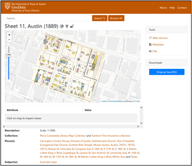
Over the past five years, great strides have been made in enhancing access to the UT Libraries (UTL) maps and geospatial collections. The UT Libraries has for decades been committed to making copyright-free maps from its collections freely available online. This commitment has resulted in the scanning and sharing of tens of thousands of maps from the renowned Perry-Castañeda Library Map Collection (PCLMC), which have been made available for download online for over 25 years. The Libraries’ focus on sharing its geospatial data has also more recently led to the development of the Texas GeoData portal in 2019, which has been a game-changer for enhancing discovery and use of geospatial data and maps from the UT Libraries’ collections. This portal enables access to a wide variety of geospatial data types available for download, including georeferenced scanned maps from the PCLMC and geospatial datasets developed from collections in the Alexander Architectural Archives and the Benson Latin American Collection.
In 2021, the UT Libraries Map & Geospatial Collections Explorer Fellowship was created to incentivize engagement with the Libraries’ geospatial materials like those shared through the PCLMC site, the Texas GeoData portal, the UT Libraries Collections portal. This Fellowship has been designed to both support the work of UT researchers and scholars who utilize UTL map and geospatial assets in their projects and to encourage further enrichment and promotion of the UT Libraries’ map and geospatial collections. The Explorer Fellowship is now offered annually, with two separate award categories: one for UT students of all levels and the other for faculty and post-docs.
On August 22, UTL launched the call for proposals for the 2022 Fellowship awards. Proposals are due October 3, and the Faculty and Student award winners will be announced on GIS Day, November 16, 2022.
Here are some fast fun facts about the Explorer Fellowship to pique your interest:
- Fellowship awards are $1500 each, with half distributed upon announcement of Fellowship recipients and half distributed after completion of Fellowship requirements.
- Two Fellowships are offered annually, one for active UT students and one for UT faculty and postdocs in current paid appointments.
- Fellowship recipients will have their work featured and preserved in one or more UTL repositories, such as Texas ScholarWorks and the Texas Data Repository.
- Maps and geospatial assets that are improved or enhanced by Fellowship awardees will be shared with others through the Texas GeoData portal.
- Fellows will have the opportunity to meet and consult with UTL map collections and GIS experts Katherine Strickland and Michael Shensky for project insights and tool guidance.
- Researchers selected for Fellowship support will join the nascent ranks of previous recipients doing impressive work whose projects are described below.
Bailey is studying critical watersheds in Puerto Rico (PR) and their downstream fresh-water reservoirs in order to quantify sediment accumulation rates and identify environmental controls on erosion. She is using maps from the Perry-Castañeda Library Map Collection to characterize past land use in PR and determine their influence on sediment accumulation. She plans on publishing a database of bathymetric data in the UTL repositories with pre-existing bathymetric data from government agencies as well as new data she will be collecting using a bathymetric hydro-drone.
The threat from sea-level rise to the Texas coast, which produces ~$400 billion in economic value, is increasingly visible with widespread impacts across human, built, and natural environments. This project plans to build a map of coastal change for the State of Texas to enable the detection of the regions of greatest change (hotspots). By studying hotspot locations in conjunction with environmental data, we can understand the processes responsible for change and how such regions might be impacted from future sea level rise. Map data will be superimposed with demographic data to determine the coastal populations most at risk from sea level and associated threats.
Curious to know more? Visit the UTL Map & Geospatial Collections Explorer Fellowship LibGuide.
Take a look at the Call for Proposals document for ideas about using geospatial collection items in research you’re planning. It’s possible your project could be elevated by these materials, and incorporating them would enable you to meet the Fellowship application requirements. Please also feel free to share this information about the Explorer Fellowship with any friends or colleagues that you think might be interested in this opportunity.